If you’ve ever searched for the best fishing spots near me, you’ve probably realized quickly—good spots aren’t given, they’re found. Whether I’m chasing redfish on the Texas flats, targeting speckled trout in moving tides, or hiking into backcountry streams for fly fishing, my approach stays the same: read the water, understand the conditions, and let the fish tell you where they want to be.
In this guide, I’ll break down exactly how I find productive fishing locations anywhere—using real tactics, tools like Google Earth, tide and current data, and on-the-water experience fishing areas like Galveston, Freeport, and Matagorda.
“The best fishing spots aren’t spots—they’re conditions lining up in the right place.”
Understanding What Makes the Best Fishing Spots
Before even opening a map, I’m thinking about what the fish need:
• Moving water (tides, current, inflow/outflow)
• Bait presence (shrimp, mullet, crabs, shad)
• Structure (grass flats, drop-offs, points, drains)
• Water clarity
• Wind direction and protection
This applies whether you’re:
• Fishing inshore for redfish and trout
• Targeting largemouth bass in ponds or lakes
• Hiking into backcountry fly fishing streams
Fish don’t randomly sit somewhere—they position themselves where food is brought to them.
How I Use Google Maps & Google Earth to Find Fishing Spots
This is where everything starts.
1. Scouting Structure from Above
Using Google Earth and satellite view, I look for:
• Grass flats and sand pockets (redfish & trout)
• Shoreline points and coves
• Drains and cuts between marsh systems
• Drop-offs and depth changes
• Creek bends and riffles (for trout streams)
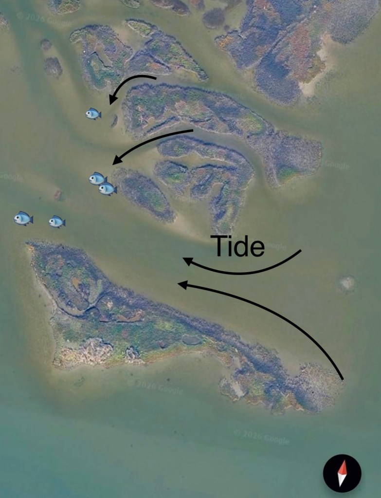
2. Identifying Water Movement
I zoom in on:
• Narrow channels
• Marsh drains
• Inlets and bay connections
These areas concentrate bait—especially on moving tides.
3. Finding Access Points
For real-world usability, I mark:
• Kayak launches
• Wade fishing shorelines
• Public bank access
• Bridges and roadside pull-offs
“A great spot doesn’t matter if you can’t safely and consistently access it.”
Using Tides and Currents to Pinpoint Fish (Inshore Focus)
Fishing the Texas coast—especially around Galveston—tides are everything.
Click on the two images below to see tides and currents in your area

Incoming Tide (Flood Tide)
• Water pushes bait onto flats
• Redfish move shallow to feed
• Cleaner water often follows
Outgoing Tide (Ebb Tide)
• Bait gets pulled out of marshes and back lakes
• Fish stack in drains and pinch points
• Bite windows can last longer here
What I Look For
• Light to moderate current (not ripping)
• Clear to slightly stained water
• Wind-protected shorelines
“If bait is moving, fish are feeding. If the water is dead, keep moving.”
Finding Redfish & Trout in Areas Like Galveston, Freeport, and Matagorda
In these systems, I focus on high-percentage zones:
Key Areas
• Marsh drains on falling tides
• Grass flats on incoming tides
• Shorelines with bait activity
• Sand pockets mixed with grass
What I Watch For
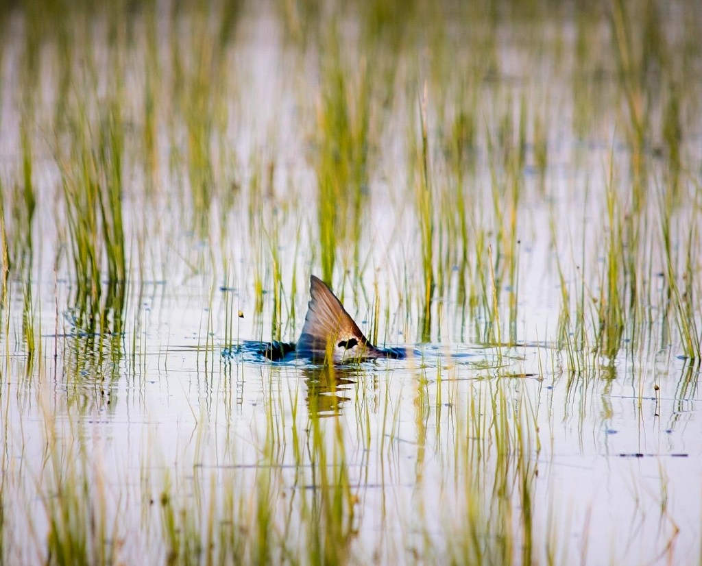
• Mullet flipping
• Nervous water
• Wakes and pushes
• Birds working
When I start seeing life, I slow down and fish thoroughly.
Kayak, Wade, and Bank Fishing Strategy
Kayak Fishing
• Launch near marsh systems or flats
• Use wind to drift quietly across structure
• Cover water until you find bait/activity
Wade Fishing
• Target clear water flats and shorelines
• Move slow and watch for signs before casting
• Focus on transitions (grass to sand, shallow to drop-off)
Bank Fishing
• Bridges (current + structure)
• Ponds with inflow/outflow
• Public shoreline access with depth change
“Mobility is everything—don’t get locked into one spot.”
How I Find Freshwater & Bass Fishing Spots Near Me
When I switch to bass fishing, the mindset stays the same.
What I Look For
• Points and submerged structure
• Grass lines and edges
• Shade (docks, trees, overhangs)
• Inflow areas (creeks, drains)
Using Google Maps, I scan:
• Retention ponds
• Small lakes
• River access points
If water has structure + bait + access, I’m fishing it.
Backcountry Fly Fishing: Finding Remote Water
This is where things get even more strategic.
Tools I Use
• Google Earth (topography + water flow)
• Trout routes and public land maps
• Elevation and gradient changes
What I Look For
• Small streams off main rivers
• Pocket water and riffles
• Undisturbed areas away from pressure
Key Indicators
• Cold, moving water
• Oxygen-rich sections (riffles, runs)
• Access via trails or public land
“The harder it is to get to, the better the fishing usually is.”
Reading Conditions Over Spots
One of the biggest mistakes anglers make is chasing spots instead of patterns.
Instead, I focus on:
• Water movement
• Bait activity
• Seasonal behavior
• Weather changes
That’s how you can go anywhere—even a completely new area—and still find fish.
Final Thoughts: Build Your Own Fishing Map
Over time, I build a mental (and digital) map of:
• Productive tides
• Reliable areas
• Seasonal movements
Every trip adds data.
“The more water you study, the less you rely on luck.”
